Central Meteorological Observatory: In the next three days, large-scale rain and snow will continue in the central and eastern regions.
Cctv newsAccording to the Central Meteorological Observatory, it is predicted that a large range of rain and snow weather will continue in the central and eastern regions in the next three days, and there will be high risk of snowstorm, low-temperature rain and snow freezing in parts of central Inner Mongolia, southwestern Shaanxi, northwestern Shanxi, northern and southern Hebei, Beijing, Henan, Shandong, eastern Jilin and eastern Liaoning, and attention will be paid to the impact on transportation, communication facilities, agriculture and animal husbandry. Strong cold wave weather affects most parts of China from west to east, so we should pay attention to the influence of low temperature on energy supply, and the offshore waters should also pay attention to the harm of strong wind.
There is a wide range of rain and snow in the central and eastern regions.
From December 14th to 15th, there was a large-scale rain and snow weather process in the central and eastern regions, with small to medium snow in the central and eastern regions of northwest China, Inner Mongolia, North China, north-central Huanghuai, Liaoning and Jilin, including heavy snowstorms, local blizzards or extremely heavy blizzards in parts of southwestern Shaanxi, southern North China, northern Huanghuai, eastern Liaoning and eastern Jilin. There are freezing rains in parts of southwestern Shaanxi, Henan, central Shandong, western and northeastern Hubei, and western Anhui; There are moderate to heavy rains in southern Huanghuai, Jianghuai, Jianghan, Chongqing and Jiangnan, with local heavy rains and some areas accompanied by overhead thunderstorms.
The Central Meteorological Observatory continued to issue a yellow warning of blizzard at 06: 00 on December 14th:From 08: 00 on December 14th to 08: 00 on December 15th, there were heavy blizzards in parts of central Inner Mongolia, southeastern Jilin, eastern Liaoning, southeastern Shaanxi, northwestern Hubei, most of Henan, northern Anhui, central and western Shandong, southern Hebei, etc. Among them, there were heavy blizzards or extremely heavy blizzards (30-35 mm) in eastern Qinling of Shaanxi, northwestern Hubei and mountainous areas of western Henan. The newly added snow depth in some areas above is 3 ~ 8 cm, and the local area can reach more than 15 cm (see Figure 1).
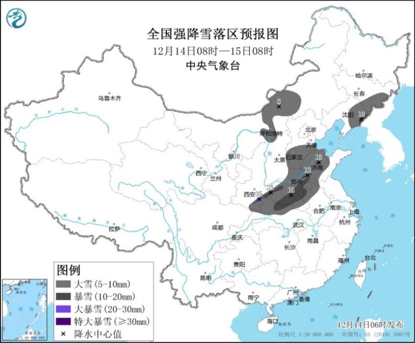
Figure 1 Forecast Map of Heavy Snowfall Area in China (08: 00 on December 14th-08: 00 on December 15th)
From 08: 00 on December 15th to 08: 00 on December 16th, there was heavy snow in parts of eastern Jilin and northeastern Liaoning, among which there was heavy snow (10 ~ 11 mm) in Changbai Mountain area in eastern Jilin. The newly added snow depth in some areas above is 3 ~ 8 cm, and the local area can reach more than 10 cm (see Figure 2).
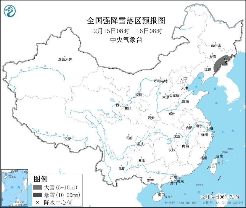
Figure 2 Forecast Map of Heavy Snowfall Area in China (08: 00 on December 15th-08: 00 on December 16th)
The Central Meteorological Observatory continued to issue a frozen yellow warning at 6: 00 on December 14.From 08: 00 on December 14th to 08: 00 on December 15th, there was freezing rain in parts of southern Shaanxi, western and northeastern Hubei, western Anhui, most of Henan and central Shandong (see Figure 3).
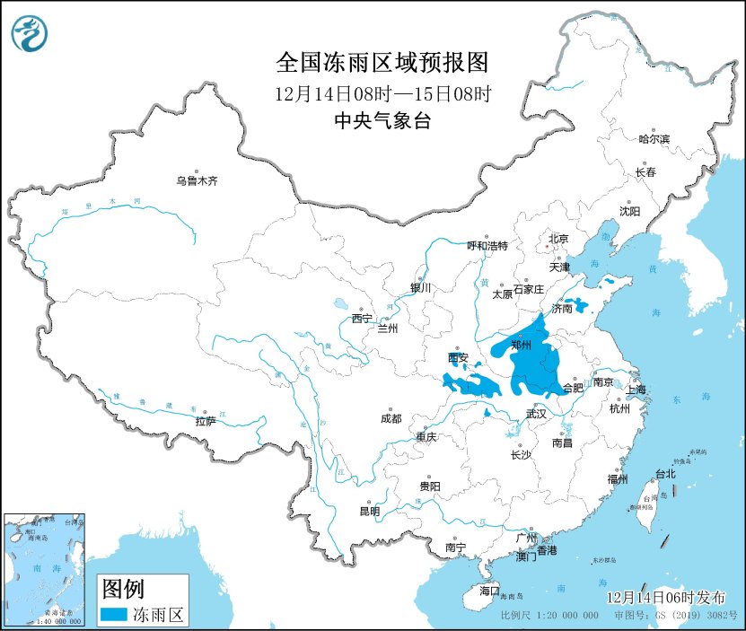
Figure 3 National Freezing Rain Regional Forecast Map (08: 00 on December 14th-08: 00 on December 15th)
Strong cold wave continues to affect most parts of China.
The Central Meteorological Observatory continued to issue a cold wave yellow warning at 06: 00 on December 14:From December 14th to 16th, a strong cold wave will affect our country from west to east and from north to south. In most areas, northerly winds of magnitude 4 ~ 6 will appear successively, and the temperature will drop by 8 ~ 12℃. The temperature will drop above 14℃ in parts of central and northern Shaanxi, central Inner Mongolia, eastern Liaoning, southeastern Jilin, northern and western Shanxi, northern Hebei, eastern Henan, most of the south of the Yangtze River, southeastern Southwest China and most of southern China. There are 6-8 grades and 9-10 gusts in the eastern and southern seas. On the morning of 17th, the lowest temperature line of 0℃ can be pressed south to southern Guizhou and northern Jiangnan, and the line of -10℃ is located from northern Huanghuai to Qinling. The lowest temperature in some areas of North China, northern Huanghuai and other places will approach or fall below the historical extreme value in the same period. Among them, from 08: 00 on December 14th to 08: 00 on December 16th, the temperatures in central and western Inner Mongolia, most parts of northwest China, North China, Huanghuai, Jianghuai, Jianghan, most parts of south China, eastern part of southwest China and most parts of south China will drop by 8 ~ 12℃ successively, and the temperatures in central and northern Shaanxi, northwestern and western Shanxi, central Inner Mongolia, southern Jiangnan, southeastern part of southwest China and northern part of south China will drop by 14 ~ 16℃ successively.
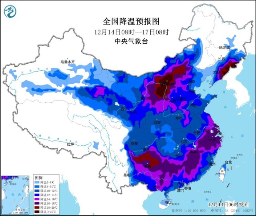
Figure 4 National Cooling Forecast Chart (08: 00 on December 14th-08: 00 on December 17th)
Domestic specific forecast for the next three days
From 08: 00 on December 14th to 08: 00 on December 15th,There are small to medium snow or sleet in parts of the central and eastern northwest, central and southeastern Inner Mongolia, Jilin, Liaoning, North China, most of Huanghuai, western Jianghuai and northern Hubei, among which there are heavy blizzards in parts of central Inner Mongolia, southeastern Jilin, eastern Liaoning, southeastern Shaanxi, northwestern Hubei, most of Henan, northern Anhui, central and western Shandong, southern Hebei and other places, and there are local blizzards in eastern Qinling of Shaanxi, northwestern Hubei and mountainous areas of western Henan. There are moderate to heavy rains in parts of eastern Jianghuai, most of Jianghan, northern and western Jiangnan, and Chongqing. There are 4 ~ 6 winds in parts of western Inner Mongolia and Hexi, Gansu (see Figure 5).
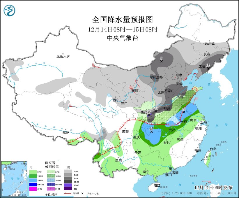
Figure 5 National Precipitation Forecast Chart (08: 00 on December 14th-08: 00 on December 15th)
From 08: 00 on December 15th to 08: 00 on December 16th,There are small to medium snow or sleet in parts of the southeastern part of Northwest China, eastern Inner Mongolia, south-central part of Northeast China, southern part of North China, Huanghuai, western Jianghuai, most of Jianghan, northern Sichuan Plateau, northern Sichuan Basin and western Guizhou. Among them, there are heavy snowstorms (10 ~ 11 mm) in parts of eastern Jilin, northeastern Liaoning and northern Shandong Peninsula. There is freezing rain in Guizhou and other places. There is moderate to heavy rain (25 ~ 40 mm) in parts of eastern Jianghuai, eastern Jiangnan, most of Fujian and northern Guangdong. There are 4 ~ 6 winds in the eastern part of Northwest China, central and eastern Inner Mongolia, Jilin, Liaoning, North China, northern and western Huanghuai, eastern Jianghan, northern and eastern Jiangnan, and coastal areas of South China (see Figure 6).
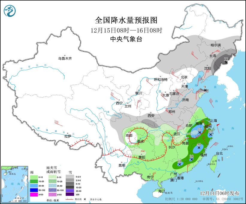
Figure 6 National Precipitation Forecast Chart (08: 00 on December 15th-08: 00 on December 16th)
From 08: 00 on December 16th to 08: 00 on December 17th,There are small to medium snow or sleet in some areas of western mountainous areas of southern Xinjiang, eastern Heilongjiang, most of Jilin, northeastern Liaoning, Liaodong Peninsula, Shandong Peninsula, eastern Chongqing and central and northern Guizhou, among which there is heavy snow (5 ~ 8 mm) in some areas of northern Shandong Peninsula. There is freezing rain in Guizhou and other places. There is light rain in parts of south-central Jiangnan, eastern Sichuan Basin and most of southern China. There are 4 ~ 6 winds in parts of central and eastern Inner Mongolia, Liaodong Peninsula, northern North China, Shandong Peninsula, eastern Jiangnan and coastal areas of South China (see Figure 7).
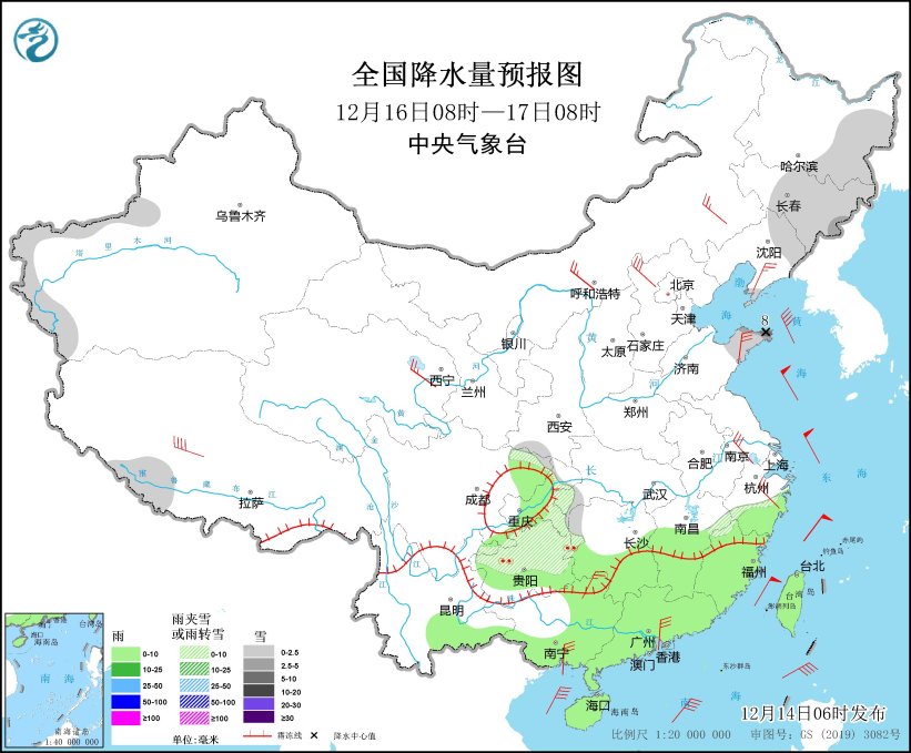
Figure 7 National Precipitation Forecast Chart (08: 00 on December 16th-08: 00 on December 17th)